Our motto: Hike more, worry less…
5 Day Hike
The Giant’s Cup Trail is part of the National Hiking Way, leading you through the foothills of the southern sections of the Maloti-Drakensberg Park World Heritage Site. This trail begins at the spectacular Sani Pass and meanders along remote paths, streams and valleys in the rugged Drakensberg foothills. Your overnight accommodation is in five delightful, but minimally equipped huts or converted houses. The trail finishes at Bushman’s Nek in the extreme south of the Park. The Maloti-Drakensberg Park was given World Heritage Site status for a combination of two factors – its outstanding natural landscapes, and its wealth of Sanrock art – a priceless cultural and natural heritage. It is one of 23 other protected areas globally to be inscribed for this fascinating combination.
Although the hiking is not particularly strenuous, the Drakensberg range should never be taken lightly. Snow has fallen in these mountains in every month of the year in the past, and the weather can change for the worse extremely quickly.
In the summer months an afternoon thunderstorm is a common occurrence, so you are strongly advised to be at your next overnight stop soon after lunch each day. There is a double benefit in this, you have the shelter of the overnight hut should a thunderstorm break over your party, and you have time to enjoy the area around it ─ swim in the clear ‘berg streams, take photos or simply relax. The distances between the overnight points are not great, and this allows plenty of time to enjoy the mountains. You need to remain aware of time, however, so that you arrive at your overnight point with plenty of daylight to spare.
Before you start the trail or at the end of the first day, you are required to visit the Wildlife Office at Cobham where you must complete the Mountain Rescue Register, which is kept in a small information centre near at the reception office and is open 24 hours a day.
Your entry in the Register provided by the staff with vital information about your party, its route, equipment, food supplies and numbers of people. This information is critical in organising a search and rescue operation in the event of an emergency. Please fill in ALL the required information clearly and accurately. Please note that there is a tear-off section listing emergency telephone numbers. Please take this with you and keep it in a safe, dry place. It may save your life. Although mobile telephone reception can be erratic it remains a rapid means of reporting an emergency. As a safety measure retain one phone in the party for emergency use only. If the phone option fails, one or two members of your party should make their way as quickly as possible to the nearest Wildlife outpost to report the emergency, leaving the remainder of the group to attend to the casualty. Do not try to contact an outside agency for assistance. This can hamper a local operation.
It is also important to sign out at office nearest your point of exit (i.e. Bushman’s Nek) at the end of the hike so that staff know that you have safely and successfully completed your hike and are out of the mountains. Failure to sign out could result in an unnecessary and costly search and rescue operation being mounted, and you could be held responsible for the costs involved. Please bear in mind that one hour of high altitude helicopter time costs about R50 000, and the average rescue takes three hours or more. The Emergency Rescue Fund covers the costs in the case of a genuine emergency.
Gianst Cup office at Cobham also sells detailed hiking maps, which include the Giant’s Cup Trail. It is recommended that each group carries copies of maps 5 and 6. These two maps cover the entire Giant’s Cup Trail. The reverse side of each map contains a wealth of information about the Drakensberg, as well as relevant information in case of an emergency. You may also book places on the trail at the last minute if there are vacancies. If the huts are already booked, you can reserve caves or camping accommodation as an alternative way of enjoying time in the Park.
Some sections of this booklet carry detailed descriptions of parts of the route to assist hikers and to provide interesting information about certain features.
Cobham
Part of the Maloti-Drakensberg Park World Heritage Site,
Cobham is a popular hikers starting point for hikes deep into the mountains.
The campsite offers open camping with ablutions. The Giant’s Cup Trail offers
many variations: one option is to complete the Sani Pass to Cobham section as a
day walk and then spend time exploring the many trails in that section. You
could also start a four-day trip along the remainder of the Giant’s
Important
You may only start your hiking trail at an official starting
point and may only stay in overnight facilities provided for this purpose.
Tents and/or camping away from the trail huts is not permitted. Please plan
your hiking trip accordingly. Hikers are requested to use only one mattress
each when staying in trail huts. Hiking is allowed only in the direction
indicated on the map and as shown by the trail markers.
All rates quoted are inclusive of Community Levy and
Emergency Rescue Levy. Accommodation fees quoted are per person per night.
Note: tariffs are subject to alteration without prior notice.
All persons of 12 years and older will be charged adult
rates. A concession equivalent to half the adult rate is available to high
school pupils undertaking the trail under the auspices of a bona fide
educational institution. This concession does not apply during school holidays,
weekends or on public holidays. Schools must make their written applications on
official stationery, which must bear the signature of the headmaster. If a
group does not wish to share with another party, a block booking and payment
must be made for the maximum number of persons (30) that can be accommodated in
each hut.
Climate
At these altitudes, nights are cool in summer and very cold
in winter. Snow can occur during any month of the year. Rain falls mainly in
summer, when mist and low cloud are common. Winter and autumn days are usually
fine and warm. The weather can, however, change rapidly. It is essential, therefore, to be fully equipped to cope
with sudden, severe changes of weather.
Rock Art
Rock art is found in many places at Garden Castle and
Cobham. The San people who left us these graphic accounts of their way of life
are long gone and their art is irreplaceable. Wetting the paintings will reduce
their life, while disfiguring them is offence punishable by law. The rock art
of the Maloti-Drakensberg Park World Heritage Site is a recognised,
international treasure, so please respect and preserve it.
Flora
Spring flowers in the Drakensberg are magnificent, although
flowers can be found at most times of the year. It may be tempting to pick them
but by doing so you will deprive someone else of the pleasure of seeing them
and disrupt an ecological process. In any case, it is a serious offence to pick
wild flowers or any vegetation in the Maloti-Drakensberg Park World Heritage
Site.
Fauna
A variety of animals may be seen along the trail, ranging
from eland to dassies (rock hyrax). Birds are less common at these higher
altitudes but birds of prey such as the jackal buzzard and Verreaux’s eagle may
be seen. You may be fortunate enough to see the endangered bearded vulture, or
Cape vulture. Leopards can occur, but are extremely shy so you are very
unlikely to encounter one.
Fires
Controlled burning is a necessary part of Park management,
but the use of this “tool” is very carefully considered and monitored.
Uncontrolled fires can be devastating. Lighting a small fire to boil water for
coffee, or a carelessly discarded match or cigarette can result in a runaway
fire that can destroy thousands of hectares of valuable grassland, cause untold
damage to vegetation, small creatures, and may even endanger human life. No
fires are permitted, other than in designated areas.
Litter
Litter is unsightly wherever it is discarded. Even a sweet
paper or piece of orange peel can mar an experience. Hikers are requested to
bring back all their refuse for disposal in the refuse bins provided at the
huts. Follow the Leave no Trace principles of “carry it in, carry it out!”
How to get there
Follow the N3 freeway taking the R617 from the Howick South/Underberg off-ramp (exit 99). Follow the R617 through Bulwer to Underberg. In Underberg turn right onto the R315 to Himeville. Approximately 2
km past Himeville, turn left onto the P318 to Sani Pass. This road, although gravelled, is accessible in all weather. Travel for a further 3,5 km past the Sani Pass Hotel which is on the right approximately 9.5 km from the Himeville turn-off.
The trail starts on the left hand side of the road at the Field Ranger Outpost car park. The South African border post is 15 km further along the road beyond the start of the trail. You may only proceed up the pass
beyond the SA border post to the Lesotho border post 6 km further in 4 x 4 vehicles. You will need a valid passport to enter Lesotho. By prior arrangement you can leave your vehicle for the duration of your trail at the Field Ranger Outpost, which is 5.6 km from the turn-off. The outpost is permanently manned. Since the trail is not a circular one, you will need either to return to your vehicle at the end of the hike or leave it at the point at which you exit the trail.
If you overnight at the Sani Backpacker Lodge or Sani Pass Hotel you can arrange to be driven to
the start of the trail but it is advisable to arrange this in advance.
Please observe the old wilderness dictum – take nothing but photos, leave nothing but footprints.
Transport and Parking
Vehicles may only be parked at Bushman’s Nek,Swayiman and Pholela huts or at the Makhakhe Field Ranger outpost at the start of the Giant’s Cup Hiking Trail. You are responsible for your own transport to the starting point and also from the end point back to your vehicle. This is not a circular route – the start and finish points are a long way apart. The road to Mzimkhulwana and Winterhoek trail huts crosses private property. Please respect this. Trespassers will be prosecuted. It is advisable to plan your hike with
these transport constraints in mind.
HIKE:
Day 1 – Pholela Hut
Giants Cup Trail Day 1: Sani Pass to Pholela Hut- Cobham Section – 13,3 km, 5 hours, (6 hours with stops)
The Giant’s Cup Hiking Trail is well demarcated with route markers – a white footprint (180 x 70 mm in size) placed on trees, rocks or poles. The trail follows the direction of the front of the foot. Numbers in the footprint indicate the number of kilometres hiked sincethe start of that day’s section of the trail. Two footprints indicate a coming change in direction of the trail, and the new direction to follow. Erosion barriers have been placed across the trail in many places along the route to channel water away from the paths. These erosion barriers are often hidden under grassy tufts, so please take care not to trip over them.
The trail starts in the parking lot at the Ezemvelo KZN Wildlife Makhakhe Field Ranger outpost 5,6 km past the Sani Pass Hotel. From the outpost, proceed about 500 m up the Sani Pass road. There is a Giant’s Cup Trail sign on the left of the road, and this marks the starting point. From the 3.7 km mark there is a good view onto the Giant’s Cup – the feature from which the trail takes its name. The Giant’s Cup itself lies in a saddle between the twin Hodgsons Peaks in the High Drakensberg.
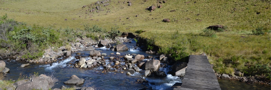
A short distance further the trail drops into the Gxalingenwa valley with the Ndlovini Hill (2 202 m) on the opposite side. In the narrow boulder-strewn valley lies the Ngenwa Pool at 4,5 km, a small natural pool on the Gxalingenwa Stream. This is an ideal spot for a refreshing swim. There are more pools a short distance upstream. The water in the Gxalingenwa Stream is drinkable, as is most water in the higher reaches of the Maloti-Drakensberg Park World Heritage Site. Please observe basic hygiene in order to keep the water pure. Relieve yourself well away from the water’s edge.
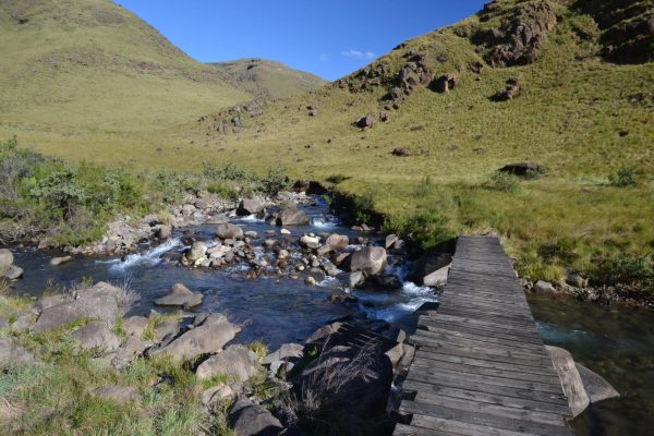
Cross the pool via the wooden bridge and continue to follow the white footprint trail markers. On the other side of the pool the trail continues left along the Ndlovini hill. A 300 m climb takes you to a cave amongst boulders and trees that hide a large open area through which the path passes. At the 5.6 km mark, the trail crosses a grassland rich in Watsonias that in spring look like an orange carpet.
From the 8,3 km point, the trail leads across a sandstone shelf at the far end of which you can see the Pholela Hut in the distance. On the valley floor the trail crosses a tributary and then the Trout Beck Stream at 10,5 km. One has to boulder hop or wade the Trout Beck several times.
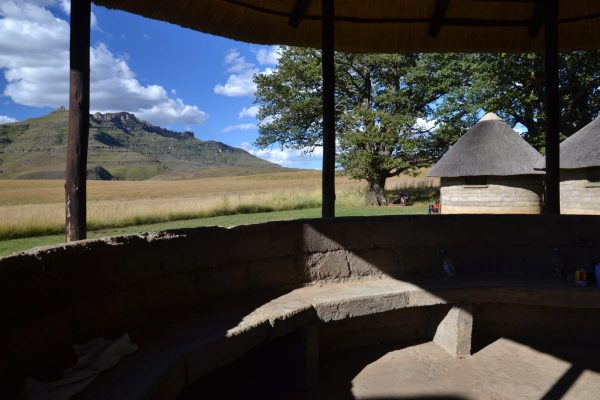
Once at the Cobham campsite and Reception Office please remember to report your arrival and fill in the Mountain Rescue Register before continuing your hike. To get to the Pholela Hut simply follow the trail markers to the swing bridge at the 13 km mark. Follow the trail past the campsite and on to the hut, which is only about 500m from the office. The small shop at the office offers maps, postcards, curios, sweets and cool drinks, and basic foodstuffs.
From the Pholela Hut head diagonally left towards a horse paddock. A sign reading “Giant’s Cup 2nd Day” points towards the Pholela River. The path winds alongside the paddock and after 100 m the Giant’s Cup Trail, with its by now familiar white footprint markers, leads to the left up a slope away from the Pholela River. After 100m some stone steps lead to the left where the trail curves uphill away from the paddock and over rocky substrate. Here, one has a lovely view onto the Giant’s Cup, while a large part of the Sani Pass – Pholela Hut section of the trail is visible to the north.
After 3 km the trail crosses a plateau, heading towards Siphongweni Ridge (2151 m). To the left lie Tortoise Rocks, a group of large sandstone boulders. The vegetation becomes denser, typical fynbos dotted with proteas, Helichrysum bushes and Leucosidea trees (Ouhout). At the 7 km marker the trail winds through protea woodland. At 7,2 km the trail crosses a small stream, and 300 m further on lies the Mzimkhulwana hut accessed via a rustic bridge over the Mzimkhulwana River.
Day 2: Pholela Hut to Mzimkhulwana Hut
Garden Castle Section – 9 km: ± 2,5 hours. (±3,5 hours with stops)
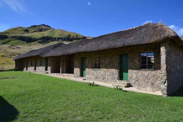
The hut consists of five rooms next to each other with three bunk beds in each room. An open area between the rooms serves as the kitchen. A small hut further upstream offers toilets, cold-water showers and hand basins. You can sunbathe on the rocks above the hut or swim in the large pool on the Siphongweni River, a tributary of the Mzimkhulwana River, about 30 m downstream of the bridge. Since the distance covered in Day 2 is quite short, there is lots of time to explore the area around the hut, swim or simply relax and enjoy the solitude and quiet of the mountains.
Day 3: Mzimkhulwana Hut to Winterhoek Hut
Garden Castle Section – 12,2 km: ±4 hours. (5 hours with stops)
From the Mzimkulwana Hut, hike back along the Siphongweni River without crossing it. The trail crosses a hanging bridge over the Mzimkhulwana River, then heads up Bamboo Mountain. After 3.5 km the path passes Crane Tarn, a small mountain lake where you may be lucky enough to see either crested or blue cranes. The two Bamboo Mountains are named after the endemic Berg Bamboo Thamnocalamus tessellatus that grows in the area.
From the ridge on Little Bamboo Mountain, one has a view lovely of Garden Castle (2 356 m) looming over a valley containing a great many homesteads. The Winterhoek Huts are at the foot of the peak under some oak trees. The trail meanders downhill on the other sideof Crane Tarn, leading through protea woodland and down to the Killicranckie Stream, so named by Scottish settlers, about 700 m below.
About 1 km on, there is a fork in the trail, the left fork leading to the Killiranckie Pool about 100 m below. The main pool has a small waterfall next to a huge boulder, and there are smaller pools close by. All are good swimming spots. The right hand fork is a continuation of the Giant’s Cup Trail. Upon reaching a stile you enter private land. The trail leads across a second stile, past some trout dams and a farmhouse, across another stile and the overflow from the trout dams another 100 m further on. Cross the track that leads to the farmhouse and follow the stream downhill, reaching the main tarred road from Underberg to the Drakensberg Gardens Hotel and the Ezemvelo KZN Wildlife Garden Castle Outpost where the fourth hut -the Swayiman Hut – of the Giant’s Cup Trail is located. Follow the road to the right for 1,7 km.
A short distance after crossing the river there is a “Castleburn Lake” sign and the familiar white footprints indicating that you need to head left over a small hill. On the other side of the hill, the trail leads through two more gates before you cross a stream below a small concrete dam and then reach Winterhoek Hut. Please properly close all gates behind you.
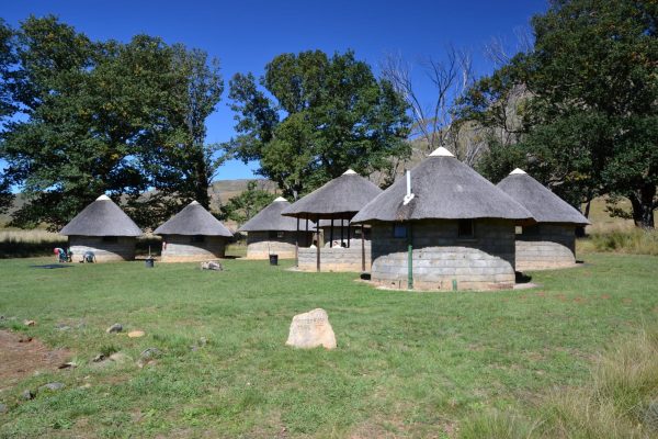
Winterhoek Hut
This hut complex consists of eight rondavels set amongst oak trees. Five of these have three bunk beds in each; one rondavel serves as a kitchen while another serves as the bathroom with cold-water showers. You may swim in the small pond above the dam.
Day 4: Winterhoek Hut To Swayiman Hut
Garden Castle Section – 12,8 km: ±4,5 hours (6 hours with stops)
On day 4, the trail winds along the slopes of Garden Castle and along the crest of a ridge stretching to the north, heading towards the escarpment. The trail passes through typical highland rich in wildflowers in spring and summer, and along Black Eagle Pass where you have a good view of the Drakensberg escarpment. It is advisable to carry extra water on this stretch.
The trail starts behind the rondavels and winds up a steep but short stretch rising 300 m, and that leads to Black Eagle Pass below the jagged peaks of Garden Castle (2 359 m). Keep an eye on the sky above, as this is the breeding and feeding range of both the Verreaux’s eagle (formerly the black eagle) and the bearded vulture. These majestic birds are often seen soaring amongst the peaks.
The trail winds across the plateau at a fairly constant height of 2 000 m, providing views of the Mlambonja and Mzimkulwana Rivers below on your right and the Mzimude River on the left. The trail winds through some protea woodlands after which you can see the Drakensberg Gardens Hotel amongst some pine trees in the valley to your right and a bit further ahead and on the left is the Ezemvelo KZN Wildlife Garden Castle Outpost and your destination – the Swayiman Hut. The trail leads above a small waterfall, and the Swayiman Hut is visible in the midst of the silvery looking trees of Garden Castle ahead. At a T-junction marked by a stone cairn, bear right for 1 km to the Swayiman Hut. If you hike the Swayiman’s Hut to Bushman’s Nek stretch the following day you will pass this same point, and will need to bear right to avoid backtracking towards the Winterhoek Hut!
Day walks from Swayiman Hut
Please enquire at the Garden Castle office for full details. There are several day walk and/or overnight options: The Monk via Sleeping Beauty Cave (sleeps 12); Engagement Cave (sleeps 2); or Cod’s Eye Caves (sleeps 4). It is necessary to book caves if you intend to overnight in them. Another option is the trail to the pools and Bushman’s Rock; or the path over Mashai Pass to Rhino Peak approximately 9 km (6 – 8 hours) via Pillar Cave (sleeps 12), and Mashai Shelter (sleeps 2).
Garden Castle Outpost
To reach the Garden Castle office follow the road leading to Swayiman Hut and turn left at the main road. Alternatively you can follow a narrow path – a short cut to the office leading from the left of the veranda. Keep left and when you reach the fenced houses, cross the access road and pass the houses on the left. Pass through a gate behind the fenced area and cross a bridge takes you over the Mashai River and to the office, where cold drinks, sweets, a few curios and basic foodstuffs are available. The road access enables you to finish your chosen part of the Giant’s Cup Trail here or to complete the Swayiman’s Hut/Garden Castle to Bushman’s Nek route as a one-day hike.
To reach the Garden Castle office follow the road leading to Swayiman Hut and turn left at the main road. Alternatively you can follow a narrow path – a short cut to the office leading from the left of the veranda. Keep left and when you reach the fenced houses, cross the access road and pass the houses on the left. Pass through a gate behind the fenced area and cross a bridge takes you over the Mashai River and to the office, where cold drinks, sweets, a few curios and basic foodstuffs are available. The road access enables you to finish your chosen part of the Giant’s Cup Trail here or to complete the Swayiman’s Hut/Garden Castle to Bushman’s Nek route as a one-day hike.
The Drakensberg Gardens Hotel offers very comfortable accommodation should you feel the need, and is about 3,5 km down the road to Garden Castle Outpost. You can take a short cut to the hotel by keeping right at the 9,5 km marker of the trail. There is also a small shop at the hotel. You are still expected to report your safe arrival and to complete any required Mountain Rescue formalities at the Garden Castle office even if you intend staying at the hotel.
Please remember to report your arrival at the Garden Castle office.
Day 5: Swayiman Hut to Bushman’s Nek Hut
Garden Castle Section 12 km: ±4 hours (5 hours with stops)
Retrace the incoming route for 1 km to a stone cairn at which the trail forks. Take the right fork. The last stretch of the Giant’s Cup Trail leads up a ridge and down into the valley of the Mzimude River and to Langalibalele Peak with an old Forestry fire lookout tower overlooking the valley.
Several high peaks to help orientate you are: Mlambonja (3 309 m), Wilson’s Peak (3 276 m), Mashai (3 313 m), Mzimude (3 210 m), Walker’s Peak (3 306 m) and Devil’s Knuckles (3 028 m). At 4.8 km a secondary trail branches off the Giant’s Cup Trail, heading up towards Hidden Valley through which the Mzimude River flows.
After crossing the Mzimude River, keep right past the old fire-lookout on the ridge above you and head towards Langalibalele Peak and to the saddle to the right of the peak. From this saddle (10,4 km) there is a good view down the valley to the Bushman’s Nek Hotel. High up to the right you can see the Devil’s Knuckles in the High Drakensberg , these peaks lie at the northern end of the Sehlabathebe National Park in Lesotho. At 11,8 km you will reach a junction with a sign indicating Bushman’s Nek Hut to the right. The hut is about a ten-minute walk from there. The police station lies about 1 km along the track to the left. You can overnight at the Bushman’s Nek Trail Hut, drive back to Himeville or stay in the nearby Bushman’s Nek Hotel. Please remember to sign the Mountain Rescue Register at the Ezemvelo KZN Wildlife office to show that you have completed the hike and are out of the mountains.
OVERNIGHT HUTS:
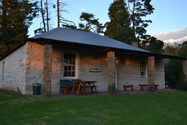
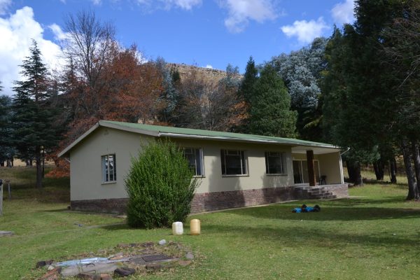
Pholela Hut – Electricity, flush toilets
The hut is an old farmhouse with 30 bunk beds in four rooms. Two of the rooms have built-in fireplaces. There is a toilet and bathroom with one basin and two showers; a second bathroom with a toilet and showers is accessed from outside the building. There is a covered braai area in front of the building
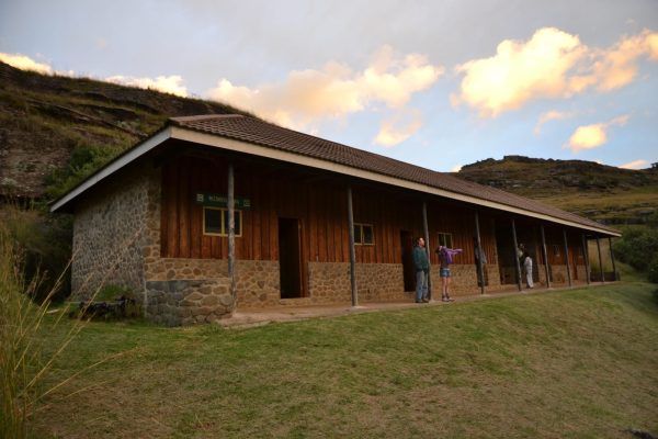
Swayiman Hut Electricity, flush toilets
This hut is an old forestry house that has electricity and hot showers. In this large house there are toilets and showers, a kitchen and a lounge with a fireplace as well as three bedrooms with four, four and six bunk beds respectively. The veranda offers a good view of Swayiman Peak (2 430 m).
Day 5: Bushman’s Nek Hut – Cold water
Day 5: Swayiman Hut to Bushman’s Nek Hut, Garden Castle Section
12 km: ±4 hours (5 hours with stops)
Retrace the incoming route for 1 km to a stone cairn at which the trail forks. Take the right fork. The last stretch of the Giant’s Cup Trail leads up a ridge and down into the valley of the Mzimude River and to Langalibalele Peak with an old Forestry fire lookout tower overlooking the valley.
Several high peaks to help orientate you are: Mlambonja (3 309 m), Wilson’s Peak (3 276 m), Mashai (3 313 m), Mzimude (3 210 m), Walker’s Peak (3 306 m) and Devil’s Knuckles (3 028 m). At 4.8 km a secondary trail branches off the Giant’s Cup Trail, heading up towards Hidden Valley through which the Mzimude River flows.
After crossing the Mzimude River, keep right past the old fire-lookout on the ridge above you and head towards Langalibalele Peak and to the saddle to the right of the peak. From this saddle (10,4 km) there is a good view down the valley to the Bushman’s Nek Hotel. High up to the right you can see the Devil’s Knuckles in the High Drakensberg , these peaks lie at the northern end of the Sehlabathebe National Park in Lesotho. At 11,8 km you will reach a junction with a sign indicating Bushman’s Nek Hut to the right. The hut is about a ten-minute walk from there. The police station lies about 1 km along the track to the left. You can overnight at the Bushman’s Nek Trail Hut, drive back to Himeville or stay in the nearby Bushman’s Nek Hotel. Please remember to sign the Mountain Rescue Register at the Ezemvelo KZN Wildlife office to show that you have completed the hike and are out of the mountains.
Bushman’s Nek Hut
Bushman’s Nek Hut is similar to the Mzimkhulwana Hut having five rooms adjoining one another. The toilets and cold-water showers are located between the rooms. To reach the police station and parking lot follow a path below the hut. It’s a 15-minute walk Day walks from Bushman’s Nek – There are opportunities to do day walks and visit caves in this area, e.g. Lammergeier Cave via Ngwangwane River. You also have the opportunity to walk to Sehlabethebe Lodge, which is located in Sehlabethebe National Park in Lesotho via the Bushman’s Nek Pass. To do this you will need to complete passport formalities at the border posts of both South Africa and Lesotho.
Note: The Swayiman and Pholela huts may be booked independently, provided that a hiking party of 30 is not traversing the trail. These huts may only be booked a fortnight in advance. At least one adult must accompany each group of up to ten persons under the age of 18 and hikers must stay on the marked route in groups of not less than three persons. The receipt printed on the confirmed reservation advice form will serve as the official permit to undertake the hike and must be produced for inspection if required. Keep it in a safe, dry place
Day three (5,5 hours – 12,2 km)
Pleasant vistas present themselves on the long climb towards the Little Bamboo Mountain, named after the indigenous bamboo found here. Blue cranes frequent the area around Crane Tarn and Scottish names such as Inverness and Stromness have been given to farms by early Scots settlers. The Killiecrankie pools tempt one to swim in the clear, fresh mountain water. The lovely old oak trees around Winterhoek Hut were probably planted at about the end of the nineteenth centuary.
Overnight at Winterhoek Hut in Garden Castle.
Day four (6 hours – 12,8 km)
Be sure to fill your water bottle as few streams flow along this section of the trail during the dry season. There is a steep climb up the slopes of Garden Castle, after which the trail is relatively level to Swiman Hut. Overnight at Swiman Hut in Garden Castle.
Day five (4 hours – 12 km)
From Swiman Hut the trail crosses into the wide Mzimude valley, climbs again towards the fire look-out post passing Langalibalele cave which has Bushmen paintings. Here again please do not deface/write, scratch, pour water on, or touch the paintings. Sleeping in Langalibalele cave is prohibited.
The Bushman’s Nek Hut is on a short spur off the trail and can be by-passed by those not spending the night there. The trail ends at the parking area close to the Reserve entry point.
This hut is an old forestry house that has electricity and hot showers. In this large house there are toilets and showers, a kitchen and a lounge with a fireplace as well as three bedrooms with four, four and six bunk beds respectively. The veranda offers a good view of Swayiman Peak (2 430 m).
Garden Castle Outpost
To reach the Garden Castle office follow the road leading to Swayiman Hut and turn left at the main road. Alternatively you can follow a narrow path – a short cut to the office leading from the left of the veranda. Keep left and when you reach the fenced houses, cross the access road and pass the houses on the left. Pass through a gate behind the fenced area and cross a bridge takes you over the Mashai River and to the office, where cold drinks, sweets, a few curios and basic foodstuffs are available. The road access enables you to finish your chosen part of the Giant’s Cup Trail here or to complete the Swayiman’s Hut/Garden Castle to Bushman’s Nek route as a one-day hike.
To reach the Garden Castle office follow the road leading to Swayiman Hut and turn left at the main road. Alternatively you can follow a narrow path – a short cut to the office leading from the left of the veranda. Keep left and when you reach the fenced houses, cross the access road and pass the houses on the left. Pass through a gate behind the fenced area and cross a bridge takes you over the Mashai River and to the office, where cold drinks, sweets, a few curios and basic foodstuffs are available. The road access enables you to finish your chosen part of the Giant’s Cup Trail here or to complete the Swayiman’s Hut/Garden Castle to Bushman’s Nek route as a one-day hike.
The Drakensberg Gardens Hotel offers very comfortable accommodation should you feel the need, and is about 3,5 km down the road to Garden Castle Outpost. You can take a short cut to the hotel by keeping right at the 9,5 km marker of the trail. There is also a small shop at the hotel. You are still expected to report your safe arrival and to complete any required Mountain Rescue formalities at the Garden Castle office even if you intend staying at the hotel.
Price Available On Request
Contact 082 663 6168 or 064 523 1807
Email info@ecotrail.co.za
Disclaimer
All information adapted with permission of owner